Author Topic: Wintry Forecast for Monday 13th April 2015  (Read 5595 times)

Offline NZLW

  • Financial Supporter
  • Hero Member
  • *****
  • Posts: 1974
  • Country: nz
  • Karma: 8
    • New Zealand Local Weather Forum
Wintry Forecast for Monday 13th April 2015
« on: April 12, 2015, 10:37:31 PM »
 SEVERE WEATHER WATCH FOR GISBORNE, HAWKES BAY, WAIRARAPA, WELLINGTON, TARANAKI, TAUMARUNUI, TAIHAPE, MANAWATU, OTAGO, FIORDLAND

ISSUED BY METSERVICE AT 2105hrs 12-Apr-2015

BURST OF HEAVY RAIN FOR LOWER NORTH ISLAND, AND NORTHWEST GALES FOR THE EAST OF THE NORTH ISLAND. COLD OUTBREAK, WITH SNOW TO LOW LEVELS OVER THE SOUTH OF THE SOUTH ISLAND AND HEAVY RAIN FOR EASTERN OTAGO.

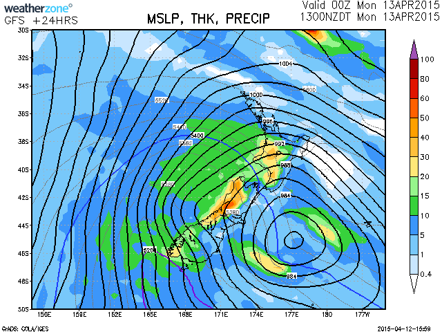
An active front preceded by a strong, moist northwest flow, moves northwards over the upper South Island tonight, then over the North Island during Monday. The front is followed by very cold southwesterlies and snow to low levels over parts of the South Island.> A period of northwest gales is expected ahead of this front, along with a burst of heavy rain which should affect western parts of the lower North Island. A Warning is in force for heavy rain the Tararua Range tonight (Sunday) and Monday morning.

This Watch is for the possibility that strong northwesterlies may rise to severe gale at times in WAIRARAPA (including the Rimutaka Hill) tonight and early Monday morning, HAWKES BAY Monday morning and GISBORNE Monday morning and afternoon.

This Watch is also for heavy rain that may approach short duration warning criteria (50mm in 6 hours) during Monday morning about Mt Taranaki and the central North Island Hill Country from eastern TARANAKI across to Tongariro National Park, and also HOROWHENUA KAPITI COAST.

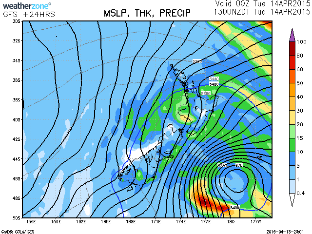
Very cold southwesterlies which are moving onto the South Island from tonight, are expected to bring snow to low levels over the lower South Island and a period of heavy rain to eastern Otago. A Warning is in force for heavy snow for southern FIORDLAND, SOUTHLAND and CLUTHA tonight (Sunday) and Monday morning.


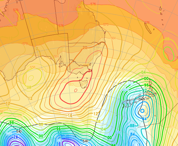
For eastern OTAGO, particularly coastal areas of CLUTHA and DUNEDIN, cold rain is expected to turn to snow above 200 metres Monday morning, with heavy snow above 400 metres where accumulations may approach warning thresholds. Below 200 metres during this time, rain is expected to become heavy, and rainfall accumulations may approach short duration warning criteria of 40mm in 12 hours.

For remaining areas of Fiordland and Otago, heavy snow of 20 to 30cm is expected to accumulate above 500 metres from Sunday evening through into Tuesday morning, and between 500 metres and 300 metres, significant accumulations are also expected and could approach warning amounts.

Note, heavy rain in the ranges of northern Westland, Buller and northwest Nelson has eased or is soon to ease, and the Watch for these areas is lifted. Also, northwest gales about inland Canterbury, Banks Peninsula and the ranges of Marlborough are no longer expected to become severe and the Watch for these areas is also lifted.


New Zealand Local Weather Forum

Offline JennyLeez

  • Administrator
  • Hero Member
  • *****
  • Posts: 10088
  • Country: nz
  • Karma: 655
  • Gender: Female
  • Wairoa
    • Wairoa, Hawkes Bay Weather
  • Station: WS3085
Re: Wintry Forecast for Monday 13th April 2015
« Reply #1 on: April 13, 2015, 12:06:30 PM »
Update from the Metservice:

SEVERE WEATHER WATCH FOR FIORDLAND, OTAGO, GISBORNE, CANTERBURY
ISSUED BY METSERVICE AT 1155hrs 13-Apr-2015

SIGNIFICANT SNOWFALLS FOR PARTS OF THE SOUTH ISLAND THROUGH TO
TUESDAY MORNING. SOUTHWEST GALES ABOUT COASTAL AREAS FROM OTAGO TO
THE KAIKOURA COAST LATER TODAY AND TUESDAY POSSIBLY SEVERE ABOUT
BANKS PENINSULA.

An unseasonably cold south to southwest flow is bringing snow to low
levels in parts of the South Island and is forecast to continue
through to Tuesday morning. The heaviest snowfalls are expected about
Southland and southern parts of Fiordland and Otago, especially
Clutha and a warning is in force for these areas.

This watch is for the possibility of significant snowfalls through to
Tuesday morning over remaining parts of Fiordland and Otago not
covered by the warning.  Note, snowfalls are also likely about parts
of Banks Peninsula and the Canterbury Plains above 300 metres,
although amounts are not expected to reach warning criteria in these
areas.

Southwest gales are also expected about exposed coastal areas from
Otago to the Kaikoura Coast from later today through much of Tuesday.
This watch is for the possibility of these gales becoming severe
about Banks Peninsula from tonight through to Tuesday night.

Finally, there is still a slight risk of severe northwest gales about
exposed higher parts of Gisborne through to mid-afternoon today and a
watch will be maintained for the time being.
Living in Wairoa, Northern Hawkes Bay
Website: wairoa.net/weather

Offline Valerie

  • Hero Member
  • *****
  • Posts: 993
  • Karma: 45
  • Gender: Female
Re: Wintry Forecast for Monday 13th April 2015
« Reply #2 on: April 13, 2015, 01:58:14 PM »
I am very pleased I live in Hawkes Bay.
Whangarei. Northland.


Share via twitter

xx
Forecast in Brief for Monday 13th July 2015

Started by NZLW

0 Replies
8125 Views
Last post July 13, 2015, 12:58:05 AM
by NZLW
xx
Forecast in Brief for Monday 27th April 2015

Started by NZLW

0 Replies
5714 Views
Last post April 27, 2015, 12:23:31 AM
by NZLW
lamp
Forecast in Brief for Monday 20th April 2015

Started by NZLW

0 Replies
5759 Views
Last post April 20, 2015, 12:18:27 AM
by NZLW
xx
A Short, Sharp, Cold Blast - Monday 13th April 2015

Started by JennyLeez

0 Replies
3773 Views
Last post April 13, 2015, 03:27:19 PM
by JennyLeez
xx
Forecast in Brief for Monday 13th October 2014

Started by NZLW

0 Replies
6450 Views
Last post October 13, 2014, 12:52:53 AM
by NZLW


For the Short Weather Forecast around New Zealand visit The Metservice.