From the NZ Herald:
Cold weather that is making its way up the country will bring showers to Auckland later this evening and into tomorrow, forecasters say.
MetService meteorologist John Law said there would be showers in Auckland throughout the rest of the afternoon.
"I think perhaps they will catch some heavier ones in the afternoon, around evening time. There are bands of showers moving through, so we will find showers on and off across Auckland today and also tomorrow as well."
Mr Law said more showers and wind was forecast for the Auckland area tomorrow.
"The temperature in Auckland tomorrow will be about 16C. [Last] Friday we got to about 25C in Auckland so it is a real contrast.'
Meanwhile severe weather watches remained in place for areas down south that were being battered by a cold front moving up the country. A front was moving across the country, followed by a cold showery southwest flow.
Snow would fall in Southland, Clutha and Fiordland, Mr Law said.
"Those guys are going to see some snowfall. The heaviest snowfall by about 600 metres. But there will be some snowfall down to lower levels as well.
"It is also very cold and windy - especially around that coast near Otago up towards Kaikoura. It is worth bearing in mind the temperatures combined with that wind will bring a significant wind chill factor."
Temperatures plummeted to -2C near Lake Tekapo last night and there would be temperatures of "similar value" tonight, Mr Law said.
The North Island would not get the same "cold cold" weather as those in the south, Mr Law said, but it would still be unpleasant.
"We've got showers across the North Island today, some of those will be heavy perhaps with a rumble of thunder, especially across the western side, from Taranaki up towards the Bay of Plenty.
"There is some snowfall about the top of the Desert Road, we have got a road snowfall warning for two or three centimeters of snowfall tonight and into Tuesday morning."
Mr Law said while today and tomorrow would be the most "active" days of weather, on Wednesday and Thursday high pressure would build.
"That will bring about some clear skies and light winds through the night time. Perfect to allow those temperatures to really drop away.
"There will be some frosty conditions perhaps Wednesday night and Thursday night."
Mr Law said winter had not come early."It's a short, sharp, cold blast of cold weather it should clear off. We are going to see temperatures pick back up again by the end of the week.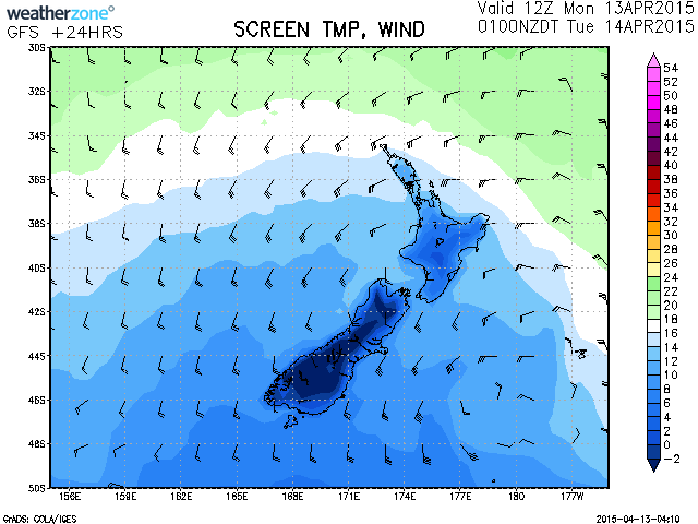


 Share Topic

