Provided by Weatherwatch.co.nz -- Rain is falling across northern and eastern parts of the North Island tonight but as expected it, for the most part, isn't too heavy. The bulk of torrential rain in tropical lows usually lies in the south eastern quadrant - and with the low north east of NZ that places the bulk of the rain well out at sea to our east. However rain is likely to intensify in some areas overnight - and there are rain warnings in force, so check MetService for their latest warnings and watches.
Gusty winds in a few areas, including Auckland, have eased a little - as the centre of the low transitions from being a tropical cyclone to being a cold centred storm. The main difference is the shape of the centre - it goes from being a tightly packed circle to being more lie an egg shape. This sends the winds in an off-kilter spin and explains why some areas are unlikely to see as damaging winds - but others may get worse.
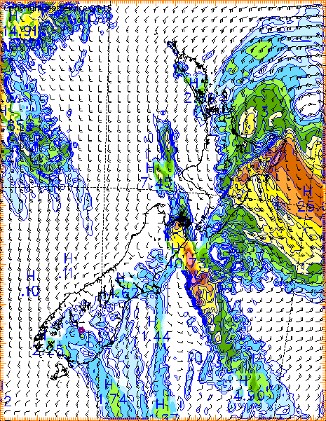
As the low moves further south the wind direction over the upper North Island will continually change. With each change in the wind direction it exposes new areas to the strong winds while protecting others. The reason why the wind/rain tends to stop in certain regions is mainly due to our many regional mountains and ranges/geography as the air flow changes direction.
Winds may ramp up even more once the low has passed south of the Auckland region (to the east of Great Barrier Island) before dawn on Monday as it looks likely to continue to transition out of being a technical 'tropical cyclone'. The 'all clear' for the north of the North Island (Auckland, Coromandel, Northland) will probably be from Monday afternoon.
The good news this evening is that winds may not be so prolonged and strong for some parts of Northland and Auckland. That's not to say powercuts and some isolated areas of damage are no longer likely - they are possible as SE to S winds swing more S to SW and may rise to severe gale for some exposed places.
Great Barrier Island itself is within the area of severe gale (or hurricane force) winds and damaging gusts are possible as the low tracks by over the next 12 to 18 hours. Bursts of heavier rain are likely overnight - but we don't anticipate major problems with rain in Auckland. In fact the rain will be helpful for the most part.
One forecast improves - another gets worse
While some in the north may not be facing such extreme conditions tonight (but please check warnings and watches from MetService in your area) - the computer models that assist us in our forecasts have tonight come together in agreement for one of the first times this week - and it places the centre of the low very close to Ease Cape. Potentially within 50 to 100kms by late Monday morning. This means hurricane force winds (sustained severe gale of 120km/h+) could hit eastern BOP, inland southern BOP, East Cape, Gisborne and northern Hawkes Bay. Winds may reach 150km/h in exposed coastal areas as the low moves closer to shore - and the ranges may fuel even stronger gusts up to 200km/h or higher.
The regions we're highlighting as being potentially the worst affected are the same ones we mentioned this past week.
Places like Whakatane eastwards and up the eastern coastline beyond Whakatane - plus inland to Kawerau and towards the eastern ranges - can expect gale force easterlies to develop tonight, turning to severe gale south easterlies during Monday, then more southerly later in the day. While the winds are E, ESE, or SE destructive gusts are possible in this eastern part of Bay of Plenty close to the ranges. Gusts in some areas (most likely right against the ranges in the foot hills and valleys) may reach between 150 and 200km/h in some pockets, thanks to the geography.
Gisborne and East Cape will be exposed to gales overnight and especially during daylight hours on Monday. Again as the centre of the low tracks by expect winds to shift from Easterlies to ESE then SE and eventually southerly. Gales are likely to climb to 150km/h for at time during the day and may be sustained severe gale (hurricane force) for a time in the most eastern, exposed, areas north of Mahia and up to East Cape.
The centre of Pam is likely to turn more southerly after it passes East Cape on Monday morning - and that means strong winds will slide down the eastern coastline as that severe 'squash zone' of gales is pushed southwards along the North Island's eastern seaboard.
The models tonight have pushed the centre of the low closer to East Cape on Monday - and therefore the belt of damaging winds and rain further west around the East Cape area - not the Northland, Auckland and Waikato areas.
This is what we talked about in earlier updates - about the 'wobbling' of the centre of cyclones - which is hard to be precise about. Even NASA cannot predict with high accuracy these 'small' dances by the inner cyclone - but these relatively small zig-zags can have big consequences for people. So we have to plan for the worst in case the low suddenly jogs sidewise.
Severe conditions ease into Monday night and Tuesday morning for most places.
For many regions this storm will not cause severe weather - but a near miss from a deadly cyclone is not a 'fizzer' and forecasts from WeatherWatch.co.nz have singled out eastern Bay of Plenty, East Cape, Gisborne and northern Hawkes Bay as highest risk areas from Pam for the past seven days.


 Share Topic

