Author Topic: Cyclone "Lusi" tracking towards New Zealand 10th March 2014  (Read 12192 times)

Offline JennyLeez

  • Administrator
  • Hero Member
  • *****
  • Posts: 10086
  • Country: nz
  • Karma: 654
  • Gender: Female
  • Wairoa
    • Wairoa, Hawkes Bay Weather
  • Station: WS3085
Cyclone "Lusi" tracking towards New Zealand 10th March 2014
« on: March 10, 2014, 10:52:40 AM »
From Weather Watch:
A potentially damaging tropical storm is on the horizon for New Zealand as various computer models agree on a similar track and intensity of the predicted low.
Various computer models have been picking this storm for well over a week now but over the past 72 hours they have aligned and that has given us more confidence".
"We still have a few days to go before we can be sure this isn't just the computers over-predicting as they do from time to time, but based on the current data we could expect damaging winds, slips and flooding as a result of this low. The models continue to paint a very serious picture and New Zealanders, especially in the north of the country, should be keeping up to date with the forecasts".
More info here:
Tropical storm may directly hit NZ (+3 maps) | WeatherWatch.co.nz
Map below courtesy of weatherwatch.co.nz


Maps below courtesy of weatherzone.co.nz
They speak for themselves :(


« Last Edit: April 12, 2014, 05:12:48 PM by JennyLeez »


Living in Wairoa, Northern Hawkes Bay
Website: wairoa.net/weather

Offline JennyLeez

  • Administrator
  • Hero Member
  • *****
  • Posts: 10086
  • Country: nz
  • Karma: 654
  • Gender: Female
  • Wairoa
    • Wairoa, Hawkes Bay Weather
  • Station: WS3085
Cyclone "Lusi" tracking towards New Zealand 11th March 2014
« Reply #1 on: March 11, 2014, 01:04:56 AM »
Update from Weatherwatch.co.nz

Tropical Cyclone Lusi has been named today by the Fiji Met Service and currently lies over Vanuatu as a category 1 tropical storm.

Winds are sustained at gale force.

Forecasters expect Lusi to grow into a Cat 3 or 4 cyclone before being technically downgraded before reaching New Zealand waters this Friday/weekend. While the storm will likely lose it's cyclone status before arriving here, it may well still retain Cat 1 or 2 strength.

The exact path of the centre of Lusi is unknown at this early stage for New Zealand but the centre could cross anywhere from Northland to just east of the North Island over the weekend.

With tropical cyclones the severe weather is near the centre - so until we can lock in exactly where the centre will track it makes it hard to pinpoint severe weather risks in NZ.  However generally speaking heavy rain could affect northern and eastern areas and severe gales could affect a number of North Island regions


Above / Saturday morning / ECMWF
Below / Saturday morning / MetOcean


« Last Edit: March 11, 2014, 01:12:56 AM by JennyLeez »

Offline JennyLeez

  • Administrator
  • Hero Member
  • *****
  • Posts: 10086
  • Country: nz
  • Karma: 654
  • Gender: Female
  • Wairoa
    • Wairoa, Hawkes Bay Weather
  • Station: WS3085
Update: Cyclone "Lusi" tracking towards New Zealand 11th March 2014
« Reply #2 on: March 11, 2014, 04:11:01 PM »
Updated Tuesday Morning --- Tropical Cyclone Lusi remains a Category 1 cyclone this morning over Vanuatu with the Fiji Met Service predicting the storm will intensfy rapidly into a Cat3 storm.

The central air pressure is currently 987hPa and is expected to drop into the 960s range before reaching New Zealand.

Overnight the computer models shifted the predicted path of Lusi closer towards New Zealand with a direct hit to the upper North Island looking increasingly likely - although still not yet locked in.

"Lusi looks like it could be a fairly intense storm when it reaches New Zealand this weekend.  The most severe weather will be wrapped around the centre when it rolls in but many North Islanders can expect a windy and wet weekend" says head weather analyst Philip Duncan.

Rain or showers, along with brisk and strengthening easterlies, will push southwards across much of, if not the entire, North Island.

The exact path of the centre of Lusi is still unknown at this stage for New Zealand but the centre looks likely to cross somewhere fom Auckland and Northland to Bay of Plenty and East Cape, as it tracks southwards then slows down and finally falls apart.

If the low makes landfall in Auckland it could also lead to coastal storm surge flooding in vlunerable places

Thanks to weatherwatch.co.nz for report.


Offline bett

  • Sr. Member
  • ****
  • Posts: 265
  • Karma: 37
  • Gender: Female
Re: Cyclone "Lusi" tracking towards New Zealand 10th March 2014
« Reply #3 on: March 11, 2014, 07:01:45 PM »
http://metvuw.com/forecast/forecast1.php?type=rain&region=nzni&tim=102

looks like a wet and windy weekend ahead for Kiwiland.

Offline JennyLeez

  • Administrator
  • Hero Member
  • *****
  • Posts: 10086
  • Country: nz
  • Karma: 654
  • Gender: Female
  • Wairoa
    • Wairoa, Hawkes Bay Weather
  • Station: WS3085
Update: Cyclone "Lusi" tracking towards New Zealand 12th March 2014
« Reply #4 on: March 12, 2014, 10:25:58 AM »
Lusi strengthening further today - landfall in New Zealand this weekend

Predicted Timeline - not specific as yet, just a rough prediction.
  • Saturday PM/early SundayAM the ex-cyclone makes landfall somewhere around Auckland/Northland/Coromandel Peninsula.
  • On Sunday the centre of the low will track southwards down the North Island.  The weather ahead of it - a bit of wind and rain - will move into northern and eastern parts of the South Island.
  • Around noon Sunday the center of the low may be around Taranaki/Wanganui area with severe weather possibly impacting parts of central NZ, however the storm is slowly starting to unwind now.
  • By Sunday night it will be crossing Wellington in a weaker state - but gales and heavy rain still possible.
  • By Sunday PM strong winds and rain may also move into Canterbury.
  • By noon Monday the storm falls apart almost completely well east of the South Island out in the Pacific Ocean.
 
Tropical Cyclone Lusi remains a strong Category 2 cyclone this morning and is likely to today reach Cat 3 strength by this afternoon as it moves away from Vanuatu and into the warm open waters of the Pacific.

Media reports yesterday say the storm has already killed one person in Vanuatu.

Data - which has been consistent about tracking this storm for 10 days now - suggests it is most likely to makie landfall in, or very near to, Auckland or Northland either late Sat PM/early Sunday AM.

The centre of the low is where the strongest winds are. Should the center of the low come in towards Auckland over the Hauraki Gulf it means the low will unlikely weaken a great deal due to that body of water - it also means areas like the eastern Waikato will be very exposed to damaging winds, Auckland may have storm surges and a period of severe gales and Northland might see wind and rain damage combined.

The center of the storm also has a storm surge - which could add to coastal flooding if the storm makes landfall during high tide.


Thanks to weatherwatch.co.nz for this report.
« Last Edit: March 12, 2014, 10:36:57 AM by JennyLeez »

Offline JennyLeez

  • Administrator
  • Hero Member
  • *****
  • Posts: 10086
  • Country: nz
  • Karma: 654
  • Gender: Female
  • Wairoa
    • Wairoa, Hawkes Bay Weather
  • Station: WS3085
Update: Cyclone "Lusi" tracking towards New Zealand 13th March 2014
« Reply #5 on: March 13, 2014, 09:22:28 AM »
Update from weatherwatch.co.nz 8.00am

Lusi is now classed as a severe tropical cyclone after reaching the predicted category 3 status overnight according to both JTWC and Fiji Met.

The storm will now travel over open waters towards New Zealand, but will start to weaken before arriving in the upper North Island over the weekend.

Winds are sustained at 120km/h with gusts to 150km/h according to JTWC.

Fiji Met Service says Lusi is expected to intensify further today.

Despite it now being just 48hours out from arriving in northern New Zealand computer models still haven't locked in an exact track for the centre of the low.  Various computer models agree the centre of the storm will likely approach Northland on Saturday, they then start to disagree about what happens next.

For example one model tracks Lusi's remains directly down the North Island while another suggests it will slide down the western side of New Zealand - something that doesn't happen too often.

"This might sound like we're splitting hairs but the difference between the center of this low tracking 100kms further west or east can have profound differences to the severe weather over land in New Zealand" says head weather analyst Philip Duncan.

Yesterday New Zealand's Ministry of Civil Defence & Emergency Management out of Wellington - which operates under Metservice advice - also launched warnings for the nation, saying this cyclone would likely "track over northern New Zealand on Saturday and Sunday and then track southwards over central New Zealand before moving out to sea east of the South Island on Monday" - which mirrors a similar forecast track by WeatherWatch.co.nz.

MetService says Lusi has the potential to be a "significant event".

WeatherWatch.co.nz maintains that damage is expected for some parts of New Zealand but that forecast needs to be balanced with the fact that larger areas will not be damaged too. 


Metservice
« Last Edit: March 13, 2014, 09:24:06 AM by JennyLeez »

Offline Mark

  • Financial Supporter
  • Hero Member
  • *****
  • Posts: 5101
  • Country: nz
  • Karma: 715
  • Gender: Male
    • Bishopdale Weather
The weekend could see Christchurch's second significant weather event in as many weeks.

Forecasters predict what's left of Tropical Cyclone Lusi will sweep down the country, bringing gale force winds and heavy rain to the city on Sunday.

Weather commentator Richard Green doesn't think it will be as damaging as the storm that buffeted the city last week.

"The rainfall the criteria it is getting close but the winds at this stage don't appear to be packing such a puncch.

"Hopefully it'll be more of a nuisance value than anything."
Mr Green says the two Autumn storms are a reminder that winter isn't far away.
North Island on standby for cyclone - Yahoo! New Zealand

Offline JennyLeez

  • Administrator
  • Hero Member
  • *****
  • Posts: 10086
  • Country: nz
  • Karma: 654
  • Gender: Female
  • Wairoa
    • Wairoa, Hawkes Bay Weather
  • Station: WS3085
Update: Cyclone "Lusi" tracking towards New Zealand 4pm 13th March 2014
« Reply #7 on: March 13, 2014, 05:42:43 PM »
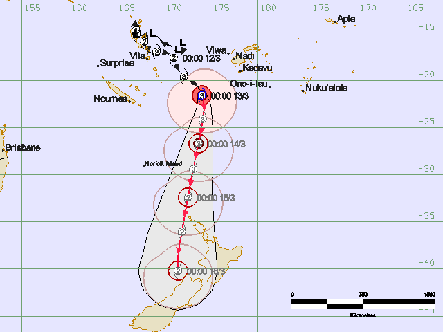
Updated 3:55pm from Weather Watch. Is she changing direction?

The exact path of Lusi over New Zealand this weekend remains unclear with computer modelling continually shifting the future track of the storm westwards.

This afternoon Lusi's wind speeds have ramped up further, according to JTWC, with winds averaging 130km/h and gusting to 160km/h.

Fiji Met says the air pressure has now fallen to 960hPa.

In the past 24 hours most reliable data has suggested the centre of the tropical low might now push west of Northland and Auckland on Saturday night/Sunday morning.

The latest data also suggests the centre of the low might track further south into the South Island now - bringing more rain and wind into the upper South Island and potentially Canterbury.

"For the working week so far the data has suggested the low would track across the North Island or along the western coastline of the North Island. Today we're seeing the high east of New Zealand pushing back a bit - helping the low sink further southwards down the South Island" says head weather analyst Philip Duncan.

"We'll need to see another 12 to 24 hours of computer runs to be certain of this developing change in the predicted track".

Mr Duncan says the high east of New Zealand is acting as leverage - helping tilt the air pressure and that shifts the direction of the low. 

WeatherWatch.co.nz says the shift in tracking will still see Northland, Auckland, Coromandel and Waikato exposed to the full brunt of the storm - which will be weakening upon arrival.  Two data updates today have weakened the low a little upon arrival - however there would need to be further similar updates before that could be locked in. 

However Fiji Met has today release a new threat map which shows the storm retaining Cat 2 status all the way to the South Island - something rarely seen.

Many farmers are wanting the rain to arrive with near-drought conditions forming in some North Isand areas.  To have the low weaken before landfall would be a positive outcome, reducing wind damage risks but still maintaining soaking rains for many areas.

In Auckland winds are likely to ramp up as Saturday ticks along.  Gales are expected to develop with the risk of severe gales in the afternoon or evening - and overnight.  If the low tracks further west than predicted it may not mean any easing in winds - instead it will change the wind direction away from ESE to more NE.

Rain may also be patchy - although patchy doesn't mean light and drizzly.  Some rain data suggests torrential downpours in the mix with lighter falls. 

"My feeling is that this low is quite complex and we may not have a truly clear picture until Saturday, at least rainwise"

The geography across the country means the wind and rain could be severe in a number of places.  "Everytime the models shift the track of the low it means all the forecasts also change - especially wind direction, which is key to working out severe gales and where highest rainfall accumulations will be".

With the low now possibly tracking further south over the South Island places like Dunedin may now have more wind and rain - along with Canterbury, Nelson and Marlborough.

"Originally it looked as though the low would take the offramp at Cook Strait to depart our shores, now it looks as though it might turn off further down the road over Canterbury and Otago".

Mr Duncan says the best advice to people is that this weekend, for many parts of the country, there will be wet and windy weather for a time "Not everyone will have severe weather or damage - but this storm is complicated and brings with it high risks for severe weather to various parts of the country".


Offline JennyLeez

  • Administrator
  • Hero Member
  • *****
  • Posts: 10086
  • Country: nz
  • Karma: 654
  • Gender: Female
  • Wairoa
    • Wairoa, Hawkes Bay Weather
  • Station: WS3085
Update: Lusi shifts her track West 14th March 2014
« Reply #8 on: March 14, 2014, 09:19:50 AM »
As Reported from weatherwatch.co.nz - 7.00am 14th March

Modelling overnight has again shifted the track of Lusi just a little - potentially moving it further west of Northland when it comes in on Saturday, but adding new risks for severe weather into the South Island.

The slight shift west of Northland potentially puts Northland and even parts of northern Auckland a little more in the path of wind - but the further west this system tracks the lower the risks for severe gales or wind damage there should be further east.

Eastern Waikato still faces potentially damaging gusts - but the highest wind peaks may not be as extreme if Lusi's path shifts even just a little further west again.

The worst of the weather is around the centre - the further the centre is away from you the less likely you are to be affecting by severe weather.  Tracking where a tropical low will make landfall is like predicting which pin a bowling ball will hit first - and sometimes they can curve away at the last minute. Lusi looks on track to hit NZ - but where it exactly makes landfall is still changing.

As you can see from the threat map below - the further west of Northland Lusi tracks, the less at risk eastern areas are.

However wind and rain are still predicted across a number of regions this weekend - the hardest part to lock down is the exact timing.

But if the severe weather risks are easing for one region - they will be increasing for another.  So keep up to date with the latest MetService warnings/watches and severe weather outlooks over the next 72 hours. 

Despite some changes in the track over New Zealand there is increasing consistency now that Lusi will slide down the North Island's west coast then track across the central South Island overnight Sunday. 

Monday may well see severe gales in eastern parts of the South Island - but one thing the data still agrees on, Lusi's remnants will be clearing the country by Monday morning.


Offline JennyLeez

  • Administrator
  • Hero Member
  • *****
  • Posts: 10086
  • Country: nz
  • Karma: 654
  • Gender: Female
  • Wairoa
    • Wairoa, Hawkes Bay Weather
  • Station: WS3085
Update: Cyclone "Lusi" - 10.30am 14th March 2014
« Reply #9 on: March 14, 2014, 10:48:08 AM »
Cyclone Lusi has moved out of the tropics and is now approaching northern New Zealand.

Lusi, currently a Category 2 tropical cyclone is lying about 800 kilometres north of Cape Reinga. Lusi's speed of movement is about 35 kilometres per  hour, and on its current track is expected to pass just to the northwest of  North Cape around midday Saturday bringing widespread heavy rain and easterly gales to the North Island from tonight (Friday night), and the upper South Island during Saturday. Rain is forecast to become heavy in Northland this evening, and 80-100mm are likely to have accumulated there by Saturday afternoon. The rain should spread quickly southwards, totalling more than 100mm in Coromandel, Bay of Plenty and Gisborne by Sunday morning.

Easterly gales will accompany the heavy rain, with severe gusts of 120km/h in Northland, Auckland and Coromandel Peninsula, and 130km/h west of the Kaimai Range.
Metservice.

Quite a significant change in track from the beginning of the week..


Offline JennyLeez

  • Administrator
  • Hero Member
  • *****
  • Posts: 10086
  • Country: nz
  • Karma: 654
  • Gender: Female
  • Wairoa
    • Wairoa, Hawkes Bay Weather
  • Station: WS3085
Update in brief: Cyclone "Lusi" hits New Zealand 14th March
« Reply #10 on: March 14, 2014, 10:31:08 PM »
Cyclone Lusi continues to slide south towards New Zealand bringing severe gales and heavy rain.

The low will track down the western side of NZ then cross over the South Island on Sunday night – before leaving the nation on Monday morning.

The rain has began to fall top of NZ with Kerikeri reporting 6.0mm at the time of posting. Wind speed has pick up to gusts of 55km/h but early days yet.
Emergency services have already been sent up top as Lusi tracks in.

Christchurch has only just dried out from massive flooding a couple of weeks ago and it appears Lusi is paying no mind to that as she will via across land Sunday.


Offline TokWW

  • Grim
  • Global Moderator
  • Hero Member
  • *****
  • Posts: 1579
  • Country: 00
  • Karma: 196
  • Gender: Male
  • Another Engineer
    • Tokoroa North Weather
Re: Cyclone "Lusi" tracking towards New Zealand 10th March 2014
« Reply #11 on: March 15, 2014, 12:54:14 PM »
A very cool digital generated Pacific map of the wind and rain patterns is here...

http://earth.nullschool.net/#current/wind/surface/level/orthographic=-184.92,-34.12,640

You can grab it with your mouse and move the globe around.  Fascinating.


Wind Map Sth Pacific Luci 150314 by suthg, on Flickr
« Last Edit: March 15, 2014, 01:06:52 PM by TokWW »


Share via twitter

xx
Recent World Disasters 19th February 2012 - Deadly Cyclone "Giovanna"

Started by JennyLeez

2 Replies
4306 Views
Last post February 21, 2012, 05:22:31 PM
by Suezy
xx
Earthquake swarm and huge "slow-slip" event at New Zealand's North Island

Started by Mark

0 Replies
2941 Views
Last post April 09, 2019, 05:47:02 PM
by Mark
exclamation
Billions of "super-Earths" 29th March 2012

Started by JennyLeez

2 Replies
4340 Views
Last post March 30, 2012, 07:09:36 AM
by ato2
smiley
Cyclone Lusi: Weekend Rainfall Tallies 15th to 16th March 2014

Started by JennyLeez

0 Replies
3194 Views
Last post March 17, 2014, 01:17:37 PM
by JennyLeez
xx
Chile's Capital In The Midst Of "Longest Cold Spell Ever Recorded"

Started by Mark

0 Replies
1150 Views
Last post May 26, 2024, 08:27:28 AM
by Mark