Author Topic: A Cold End to this Week 18th - 21st June 2015  (Read 5059 times)

Offline NZLW

  • Financial Supporter
  • Hero Member
  • *****
  • Posts: 1974
  • Country: nz
  • Karma: 8
    • New Zealand Local Weather Forum
A Cold End to this Week 18th - 21st June 2015
« on: June 17, 2015, 11:11:31 AM »
ISSUED BY MetService AT 11.00 am 17-Jun-2015

A deepening low over the Tasman Sea should approach the South Island during Thursday and cross over the far south on Friday. This low and its associated fronts are expected to bring a period of stormy weather over parts of the South Island.

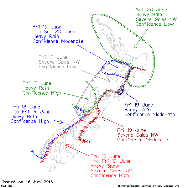
Initially, strong northwest winds are expected to affect eastern areas of the South Island, and the winds in Canterbury and Southland are likely to reach severe gale in some places this evening and during Thursday morning, with gusts of 130 km/h possible near the Canterbury Foothills.

Heavy rain is also expected to develop in Fiordland and Westland overnight Wednesday into Thursday and continue into Friday morning. During this time, 300 to 500mm of rain could fall about the ranges, although this will be heavy snow at the higher altitudes. About the Westland coast, 140 to 180mm of rain is possible.

Cold air moving onto the south of the South Island is expected to combine with the rain in southern Canterbury, Otago and Southland to bring significant amounts of heavy snow to low levels. Snow is likely to near sea-level in the south and about 300 metres in Canterbury from late Thursday morning until early Friday. Central areas of Otago are likely to be hardest hit, with accumulations reaching 15 to 25cm at 200 metres and a metre or more above about 700 metres.


Later Friday, the threat of heavy rain moves northwards. There is high confidence rainfall accumulations will exceed warning amounts about northern Westland, Buller and northwest Nelson, with the confidence lowering to moderate for the Tararua Range, North Taranaki, Waitomo and the central high country. In addition, there is moderate confidence northwest gales will become severe about remaining parts of Canterbury, Marlborough, Wellington, Wairarapa and Hawkes Bay, with low confidence western areas from Waitomo and the central North Island high country to northern Westland will experience severe northwest gales.

On Saturday, there is moderate confidence that heavy rain will continue about North Taranaki, Waitomo and the central high country, with low confidence of a period of heavy rain affecting areas further north and also Bay of Plenty, Gisborne and Hawkes Bay. In addition, there is low confidence of severe northwest gales about Northland, Auckland, Waikato, Coromandel Peninsula, Bay of Plenty, Gisborne and Hawkes Bay.

A cold southerly lies over New Zealand on Sunday as the front moves away to the northeast and a ridge approaches from the west.


New Zealand Local Weather Forum

Offline JennyLeez

  • Administrator
  • Hero Member
  • *****
  • Posts: 10088
  • Country: nz
  • Karma: 655
  • Gender: Female
  • Wairoa
    • Wairoa, Hawkes Bay Weather
  • Station: WS3085
Major Winter Storm over the South Island through to Friday
« Reply #1 on: June 18, 2015, 01:04:29 PM »
ISSUED BY MetService AT 9:16 am 18-Jun-2015

HEAVY RAIN WARNING
Westland
Heavy rain should continue into Friday morning. In the 21 hours from 9am Thursday until 6am Friday, 250 to 300mm of rain is likely about the ranges. Peak intenties of 25 to 35mm/hr this morning and afternoon. During the same period 80 to 120mm of rain is expected nearer the coast. Above about 1600 metres this rain will fall as heavy snow. Note, further rain is expected through to Friday evening.
FREEZING LEVEL: About 2000 metres

The ranges of Buller
Rain is expected to become heavy this afternoon. In the 15 hours from 3pm Thursday to 6am Friday, expect 150 to 200mm of rain. Peak intensities of 20 to 30mm/hr this evening. Coastal areas could recieve 60 to 90mm in this time.
FREEZING LEVEL: About 2400 metres.

Nelson ranges, including the Richmond and Bryant Ranges.
A period of heavy northwesterly rain is expected later today and tomorrow morning. In the 18 hours from 5pm Thursday to 11am Friday, expect 100 to 150mm of rain about the western ranges and Nelson Lakes, and 80 to 120mm of rain about the Richmond and Bryant Range.
FREEZING LEVEL: About 2400 metres.

The Tararua Range
Heavy northwestly rain is expected from tonight. In the 28 hours from 10pm Thursday to 2am Saturday, expect 150 to 250mm of rain. Peak intensities Friday afternoon and evening of 20 to 30mm/hr. Note, a significant amount of rain is possible for Wellington and the Kapiti Coast, and this will be place on a Watch.


HEAVY SNOW WARNING
Otago
Heavy snow is now expected in the north and west of the region, chiefly north of about Ranfurly and Arrowtown. In the 22 hours from 11am Thursday to 9am Friday, expect 20 to 25cm of snow to accumulate at 200 metres, with 40 to 60cm of snow possible at 700 metres. Warning amounts of snow are no longer expected for southern parts of Otago.

Canterbury
Snow is expected to lower to near sea-level Thursday afternoon. In the 18 hours between midday Thursday and 6am Friday, 20 to 30cm of snow could accumulate above about 200 metres. During the same period 40 to 60cm may accumulate at 500 metres with more than a metre possible at higher altitudes.


STRONG WIND WARNING

Canterbury, especially close to the Foothills
Severe gale northwesterlies gusting 130 km/h are likely in exposed places, easing from the south this morning and early afternoon.
Living in Wairoa, Northern Hawkes Bay
Website: wairoa.net/weather


Share via twitter

xx
Forecast in Brief for Thursday 18th June 2015

Started by NZLW

0 Replies
6079 Views
Last post June 18, 2015, 12:23:31 AM
by NZLW
xx
Forecast in Brief for Sunday 21st June 2015

Started by NZLW

0 Replies
6214 Views
Last post June 21, 2015, 01:28:18 AM
by NZLW
question
Yesterday's Highs and Lows 18th June 2015

Started by NZLW

11 Replies
7841 Views
Last post June 19, 2015, 09:51:52 PM
by Dan
question
Yesterday's Highs and Lows 21st June 2015

Started by NZLW

9 Replies
6296 Views
Last post June 22, 2015, 07:35:35 PM
by TonyC
clip
Bitter cold snap brings snow 21st July 2014

Started by JennyLeez

0 Replies
4086 Views
Last post July 21, 2014, 02:46:04 PM
by JennyLeez