Sourced from around the NZ weather site.
From weatherwatch.co.nzA humid northeasterly airflow lies over the country again today bringing rain to many areas. Watch for heavy areas of rain about Northland and Auckland today and winds rising to gale force especially about exposed eastern areas.
NorthlandRain with heavy falls, strong easterlies (gale about the eastern coastline) tend a little more southeast later in the day. Rain eases overnight.
Highs: 17-18
AucklandRain, heavy at times from midday with strong easterly winds gusting to gale
at times in exposed areas from afternoon. Rain and winds ease overnight.
Highs: 16-17
Bay Of PlentyRain with heavy falls, especially about the Coromandel and western Bay Of
Plenty. Brisk easterlies strong at times from midday.
Highs: 16-17
Waikato & Central North IslandBrisk easterly winds with periods of rain.
Highs: 12-15
Eastern North IslandRain with easterly winds, brisk from midday. Rain may become heavy
overnight about Hawkes Bay and Gisborne.
Highs: 14-16
TaranakiPeriods of rain with brisk easterly winds, rain becomes heavy from
midnight.
High: 16
Western North IslandPeriods of rain with easterly winds.
High: 14
WellingtonPeriods of rain with brisk east to southeasterly winds.
High: 14
NelsonPeriods of rain with southeasterly winds.
High: 14
MarlboroughRain with a few heavy falls, brisk easterly winds.
High: 14
CanterburyRain with a few heavy falls possible (mainly inland), breezy easterly
winds.
Highs: 11-12
West CoastMostly cloudy with morning rain becoming patchy, Fiordland stays dry for
the day although expect some high cloud. Gusty east to southeasterly
winds.
Highs: 14-15
Coastal OtagoCloudy with early morning rain easing to drizzle patches, breezy east to
northeasterly winds.
Highs: 9-10
Central OtagoCloudy periods with early drizzle patches clearing for most, about
northeastern parts of the district patchy drizzle may continue for the rest of
the day. Breezy easterlies.
Highs: 9-10
SouthlandMorning cloud breaks to a few sunny spells, breezy easterly winds.
High: 11
 From NZ Metservice
ISSUED AT 9:15 am 10-Jun-2014
Heavy rain over northern and eastern parts of both islands for the next few days. Gales for northern New Zealand this evening (Tuesday).
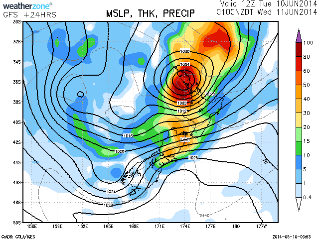
A large complex trough lying slow moving to the west of New Zealand directs a moist northeast flow over northern and central parts of the country. A deep low embedded within this trough is expected to move south over the upper North Island overnight tonight (Tuesday to Wednesday), moving the rain-band slowly south over the North Island east coast during Wednesday.
Rain is expected to persist about the northern parts of the North Island and northeastern parts of the South Island today and part of Wednesday, before spreading over eastern parts of the North Island during Wednesday and Thursday. The heaviest falls are expected about Northland, Auckland, Coromandel Peninsula, western Bay of Plenty, Marlborough and areas of the Canterbury High Country and foothills during today and early Wednesday. The heaviest falls are then expected about the Hawkes Bay and Gisborne Ranges during Wednesday and Thursday, where up to 250mm is expected to accumulate over a 48 hour period.
People are advised that these rainfalls can cause rivers and streams to rise rapidly, surface flooding, slips and make driving conditions hazardous.
Additionally, the low moving south over the upper North Island tonight, is expected to bring a period of severe east to northeast gales with gusts up to 120 km/h to parts of Northland, Auckland and the Coromandel Peninsula, with westerly gales behind the low affecting parts of Northland.
Winds of this strength have the potential to bring down trees, damage powerlines and unsecured structures.


 Share Topic

