The 7 Day Forecast from Easter Sunday forwards...
All images courtesy of MetVUW.com:
http://metvuw.com/forecast/forecast.php?type=rain®ion=swp&noofdays=7Monday
A Low still to the east of Gisborne continues to affect East Cape with cloudy days and rain from BOP to Hawkes Bay. And especially around Gisborne to Wairoa with easterlies still prevalent.

For the rest of the North Island will be southerlies but mainly clear skies after morning clouds dissipate, north of Palmerston North. Around Wellington and the Wairarapa to Hawkes Bay, could be a few coastal clouds with the cool southerlies.
The ridge of high pressure that extended in a diagonal from Sydney to the Chathams has been absorbed and diminished to a very weak anticyclone central Tasman. This leaves a south-east to easterly airstream over the east coast of the South Island and a norwest airstream over the West Coast.
A Low well to the South of Stewart Island has the most influence dragging around strong sou-westers onto Southland due to arrive on Monday night with a cold front and strong winds.
Tomorrow the Norwesters over the West Coast and Southland will pick up speed and bring cloud and rain, with some heavy showers. When the cold front comes through, temperatures will drop as it turns Sou-west with more rain and storm force winds to 100km/hr in exposed places.
Tuesday
For the first time, the East Cape sees some sunshine as the strong High to the east absorbs the Lows that have been pestering the north east coast for sometime. However, the cold front that hit Southland on Monday, rides up the South Island with South Westerlies bringing rain to the west coast and a new Low forms in the mid Tasman which deepens as it approaches the North Island.
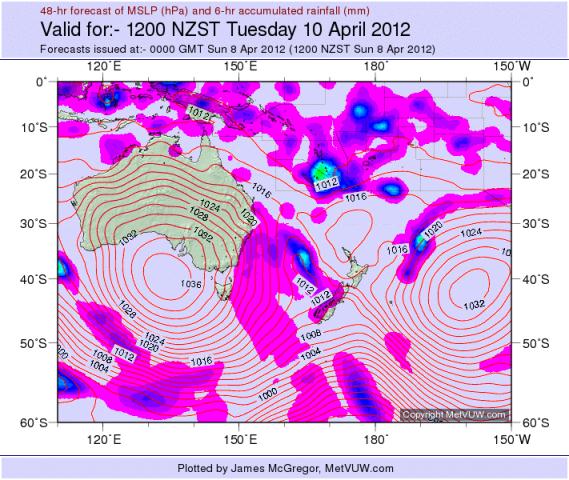
The NI for Tuesday has light variable westerly winds on the NI west coast as the Tasman High passes quickly over Northland with fine weather again over nearly the whole of the NI. Other areas in the NI can have variable Sou-West winds with moderate daytime temps into low 20’s.
The South Island will have a steady Sou-West airstream with rain covering the west coast and into Canterbury. Mid Canterbury and south to Southland on the east coast and inland will have mainly fine weather although it may be cloudy. Moderate temps in high teens.
Wednesday
The Low forming in the Tasman has moved close to New Plymouth and has deepened and will bring heavy rain over both islands from Hokitika to Ashburton and northwards in a line from Wellington through Auckland and covering Northland by midday. It will quickly progress across to the East Coast as well by evening. Strong Nor-Westers will precede it on the western coastline, winds will turn Sou-West as the cold front and Low passes and remain strong but cooler.
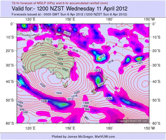
The East Cape again sees a lovely day with warm Nor-westers and sunny through most of the day. Temperatures to the mid 20’s before clouding over in the evening.
The South Island gets a mix of weather from clearing skies and sou-westers in Southland to Easterlies with heavy rain North of Christchurch. The West Coast may see Easterlies coming off the ranges with clearing skies.
Thursday
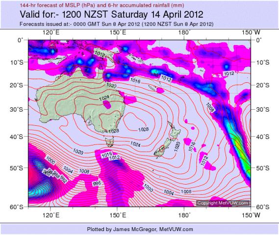
The large and deep Low to the deep south, below Tasmania has moved close to Auckland Islands and at 962hPa is very dominant with a cold front reaching up to Southland with gales and rain. It is being squashed by a large Anticyclone over Australia centred on Victoria and at 1032hPa creates a large wash of strong Sou-Westerlies across the lower Tasman right up to Tonga as these two systems – High and Low fight each other.
These will bring heavy rain for relatively short periods as the occasional cold front passes NorthEastwards over the islands.
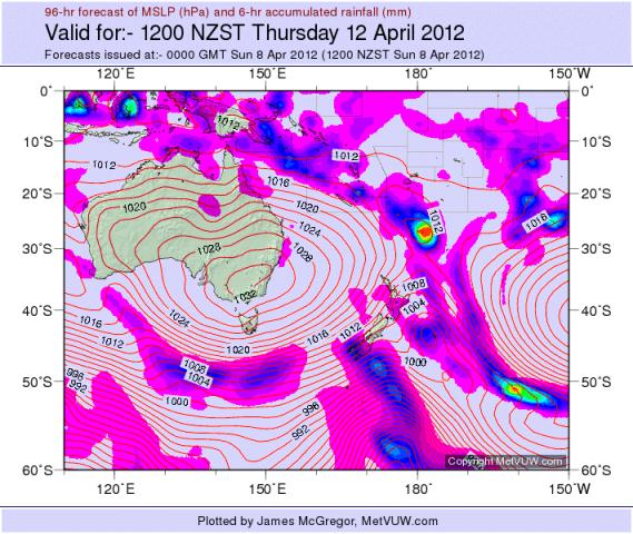
The whole country will be lashed by gale force Sou-Westerlies with mostly cloudy skies. Temperatures will be low teens for highs. Overnight, temps may drop to 5deg but not expecting any frosts anywhere with those strong winds.
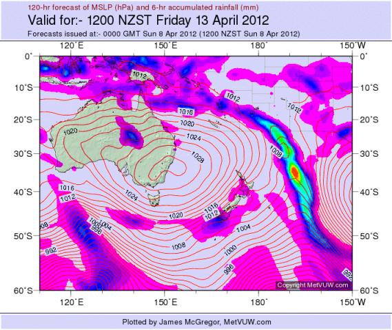
Friday
The High over Australia’s East Coast is slowly spreading onto the Tasman Sea is still the predominant force. More strong Sou-Westerlies over the whole of NZ with some passing showers associated with cold Fronts. Temperatures are cooler again. A Sub Tropical Low from Fiji has moved off to the east without affecting the NI this time.
Saturday
The clouds clear and the winds abate, still with Sou-Westers but more variable inland and sunny days again. Temps back up to the Low 20’s in inland places.
Sunday
Mainly southerly winds but light over the whole of NZ with clear fine days. A cold front and rain may hit Southland.

This forecast is from an amateur. Please do not rely on this data for accuracy and is not to be used for marine or aviation or mountain forecasts - please use the NZ Metservice for accurate and life dependent Forecasts.


 Share Topic

