isothermalsection

Author Topic: Not all Highs bring sunny weather - MetService  (Read 6674 times)

Offline TokWW

  • Grim
  • Global Moderator
  • Hero Member
  • *****
  • Posts: 1579
  • Country: 00
  • Karma: 196
  • Gender: Male
  • Another Engineer
    • Tokoroa North Weather
Not all Highs bring sunny weather - MetService
« on: April 20, 2012, 09:48:32 AM »
An interesting topic this morning on the large strong Anticyclone over NZ at present.  based on Thursday's readings, it sort of explains why some areas, especially the Eastern and coastal areas, have low level cloud and even rain during a very strong High.

Written By: Chris Webster on April 20th, 2012

On Thursday 19 April, New Zealand was completely surrounded by a very large High (or anticyclone).

The air pressure at sea level was above 1030 hPa everywhere over New Zealand at midday on Thursday. Highest pressures were over inland Otago and Canterbury, peaking at 1039 hPa. Christchurch Airport was reporting 1038.2 hPa … that’s very high indeed.

Here is a sequence of weather maps showing how the anticyclone developed over preceding days (click on the image to view animation). The first map is from midday on Thursday 12 April, and the time steps are six hours until the final map at midday on Thursday 19 April. It’s interesting how the initial anticyclone moved onto the Tasman Sea with a central pressure around 1029 to 1030 hPa, then another system came up from the Tasmania region and joined the initial system, reinforcing it.


Sequence of weather maps, 12 to 19 April 2012.


http://blog.metservice.com/wp-content/uploads/2012/04/Animation_maps.gif


This anticyclone was bringing clear, sunny weather to many places, just as typical barometers indicate on their dials when the air pressure is high. However, there were many places, particularly along eastern coasts, where the weather was not sunny at all. In fact there was even some light rain about.

Take a look at the satellite image below for details of where cloud was on the late morning of Thursday 19 April.


Image courtesy of MODIS Rapid Response Project, NASA/GSFC.


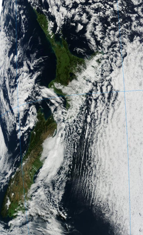
There was a lot of cloud over eastern regions, especially the east of North Island. The satellite picture showed some beautiful cloud forms over eastern Bay of Plenty… these are low clouds shaped by a combination of waves in the lee of the ranges and orientated perpendicular to the flow, and streets of cloud that are parallel to the flow.

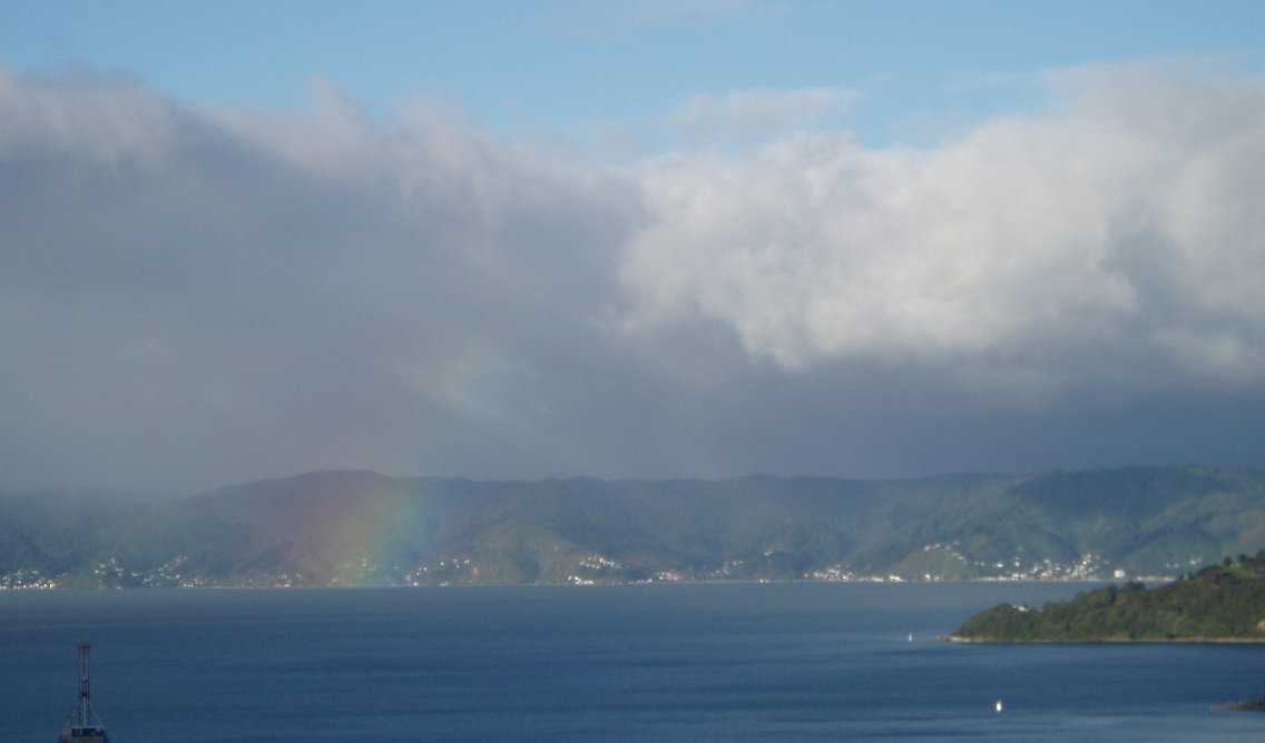
Having looked at the clouds from above, let’s also look at them from below. I took this photo of the clouds over the eastern hills of Wellington in the late afternoon of Thursday 19 April, after a rather grey cloudy day in the capital. The barometer was indicating around 1036 hPa.


Stratocumulus and low-topped cumulus cloud, Wellington, 19 April 2012.


Why is it that not all Highs bring sunny weather? It’s all to do with the upward and downward motions associated with them. Anticyclones generate sinking motion of air, as described in an earlier blog post . As the air sinks it becomes drier, and any cloud in it will generally evaporate. But this sinking air doesn’t make it all the way to the ground and, in the case of the current anticylone over New Zealand, there was a lot of moist air and cloud trapped just above the Earth’s surface.

Most of us live within a few hundred metres of sea level. If we are beneath this anticyclonic cloud, all we see is a cloudy day, even though the skies are blue above. If there’s enough low-level moisture the clouds can generate light rain or drizzle too, though it doesn’t come to much.

Wherever the wind at low levels is blowing from the sea onto the coast, it’s more likely that the air will be moist enough to bring cloud. That was the case for most eastern parts of New Zealand on Thursday 19 April. And there were some patches of drizzle and light rain about too.

Most places in the west were sheltered from the low level flow, and were indeed getting clear sunny weather.

So, with some interpretation, it’s possible to deduce quite a bit from what the barometer is measuring!


NB if someone believes we should not publish so much of this article and just provide the link then the link to the original document is here:

http://blog.metservice.com/2012/04/not-all-highs-bring-sunny-weather/

There are plenty more itneresting topics there too:  http://blog.metservice.com/


Offline Te Puke Weather

  • Financial Supporter
  • Hero Member
  • *****
  • Posts: 1168
  • Karma: 269
  • Gender: Male
  • Te Puke Weather Station
    • Te Puke Weather
Re: Not all Highs bring sunny weather - MetService
« Reply #1 on: April 20, 2012, 09:52:29 AM »
Some good points in there, thanks for posting it.
Brendan - Te Puke Weather Station

Live weather data at www.tepukeweather.co.nz

Weather Station: Digitech XC-0348

All for one, and one for all.....

Offline TokWW

  • Grim
  • Global Moderator
  • Hero Member
  • *****
  • Posts: 1579
  • Country: 00
  • Karma: 196
  • Gender: Male
  • Another Engineer
    • Tokoroa North Weather
Re: Not all Highs bring sunny weather - MetService
« Reply #2 on: April 20, 2012, 10:02:57 AM »
I'm not sure the eastern coastal and Northland cloudy and damp weather conditions were fully explained in there. 

I believe that the coastal onshore easterly winds are to blame bringing cooler moist air (cooled by evaporating the water off the warm sea into the air) then reaching landfall and the orographic hiilly nature of the east coast is causing that windy air with it's momentum, to rise up the hills and cool more causing the cloud to develope more thickly and form rain as it cools, despite the High overhead with falling dry air not completely counteracting the cool moist winds from off shore.  The clouds will be low level only with clear skies above.

Inland, yes, the effect of the High is clearly seen with descending warming dry air evaporating any moisture so it becomes invisible - clouds disappear as the sun "burns them off" as the day heats up too with some land heating involved as well.

This cloudy easterly coastline more so than Northland, will have improving weather as the High moves eastwards and the winds tend more northerly.  Then the dry and clear skies should return as the dry air flows over the hills and down to the coast - like those in Canterbury - and even days in the 20's should be on for the East Coast this weekend as the High moves away slowly. 

Northland may still have cloudy skies as the wind rotates around off the warm seas and carries more moisture with it from North-East to North and to Nor-West winds.
« Last Edit: April 20, 2012, 10:12:29 AM by TokWW »

Offline Te Puke Weather

  • Financial Supporter
  • Hero Member
  • *****
  • Posts: 1168
  • Karma: 269
  • Gender: Male
  • Te Puke Weather Station
    • Te Puke Weather
Re: Not all Highs bring sunny weather - MetService
« Reply #3 on: April 20, 2012, 10:08:48 AM »
I could be wrong, bit is that call orograhpic rain fall?

Bit like this video

Offline TokWW

  • Grim
  • Global Moderator
  • Hero Member
  • *****
  • Posts: 1579
  • Country: 00
  • Karma: 196
  • Gender: Male
  • Another Engineer
    • Tokoroa North Weather
Re: Not all Highs bring sunny weather - MetService
« Reply #4 on: April 20, 2012, 10:15:51 AM »
Yes, so true; that's why I used the term as it is the term that describes that action of moist winds from offshore reaching the slopes, physically rising with momentum, cooling and adiabatically reaching saturation point, cooling further and forcing the moisture out as rain. :)

Offline Rwood

  • Hero Member
  • *****
  • Posts: 1331
  • Country: nz
  • Karma: 244
  • Gender: Male
Re: Not all Highs bring sunny weather - MetService
« Reply #5 on: April 20, 2012, 10:33:39 AM »
Good article and responses. Today is lovely and sunny in W'gton, but the last few were very frustrating with what I would call "moist advection under an inversion", in a strong high far enough west and south in central pressure to bring onshore SE flow here. The result was very little sun for 3 straight days. The term I used above was in an article in a very old climate book about South America, Chile and Peru in particular. The "garua", which brings several very cloudy months to the Peruvian coast (and most of the Ecuadorian coast) and too a lesser extent the northern Chilean coast, was described in detail.

Offline TokWW

  • Grim
  • Global Moderator
  • Hero Member
  • *****
  • Posts: 1579
  • Country: 00
  • Karma: 196
  • Gender: Male
  • Another Engineer
    • Tokoroa North Weather
Re: Not all Highs bring sunny weather - MetService
« Reply #6 on: April 20, 2012, 10:39:05 AM »
Thanks for that, I had not checked your localised wind directions, but sou-easterly in through the Cook Strait entrance and onto the southern headlands (and the Orongorongas ?) would do that too as it did for the East Coast.  The photo in the article there showed it too.
« Last Edit: April 20, 2012, 11:17:41 AM by TokWW »


Share via twitter

xx
After El Niño, what weird weather could La Niña bring?

Started by Mark

0 Replies
2903 Views
Last post October 24, 2016, 09:43:08 PM
by Mark
xx
Britain is poised to be hit by a bout of freezing weather that could bring snow

Started by Mark

0 Replies
2660 Views
Last post October 01, 2012, 04:52:14 PM
by Mark
lamp
Sunny at Night!!!

Started by JennyLeez

14 Replies
6888 Views
Last post April 17, 2012, 05:01:48 AM
by thrashcardiom
xx
Map: How about PaulMy Temps to bring in the New Year :)

Started by JennyLeez

0 Replies
2832 Views
Last post December 31, 2016, 12:02:45 PM
by JennyLeez
xx
Ex-tropical cyclone Oma could bring more rain to the north

Started by Martin4Jay

0 Replies
2607 Views
Last post February 24, 2019, 10:34:20 PM
by Martin4Jay