A very cold southerly airstream is expected to spread over the South Island during Saturday, with snow lowering to low levels in many areas. At the same time a low pressure system from over the Tasman Sea is expected to move onto the North Island, bringing a period of heavy rain and strong winds to northern and central New Zealand.
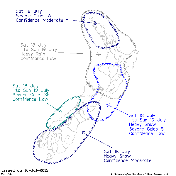
Heavy snow is expected above 500 metres over the South Island, and a warning has been issued for Fiordland, Southland, Canterbury and Marlborough for heavy snow down to 300 metres.
This WATCH also includes the possibility for a period of significant heavy snow down to 300 metres in Otago during Saturday.
Rain over northern New Zealand is likely to be heaviest in the eastern Bay of Plenty, where 80mm of rain could accumulate in a 12 to 15 hour period from midday Saturday. This rain has the potential to cause rivers and streams to rise quickly, surface flooding and make driving conditions hazardous.
Areas affected:
Eastern Northland, Great Barrier Island, the northern Coromandel Peninsula, remaining areas of the Bay of Plenty, Taranaki, Taumarunui Tongariro National Park, northwest Taihape and also Nelson. (Note this includes areas encompassing the Ruapehu District of central North Island for which there is reduced warning threshold of 50mm in 12 hours).
Additionally, strong northwesterlies over northern New Zealand are expected to turn westerly during Saturday, and there is the possibility wind could approach severe gale strength in exposed places of Northland, Auckland, Coromandel Peninsula, Waikato, Taranaki and Gisborne.
As the low moves across central New Zealand late Saturday and into Sunday, strong southerlies spread over the lower North Island, a strong wind warning is in force for severe southerly gales from Saturday evening to Sunday morning. There is also the potential the strong southerlies could reach severe gale strength in Marlborough, particularly about coastal areas, Wairarapa, the Kapiti Coast and also Taranaki.
Note, the strong southerly flow onto the lower North Island will also produce large seas which could result in coastal damage about the Wellington south coast.


 Share Topic


