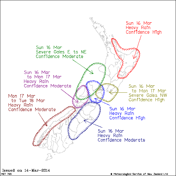
ISSUED BY METSERVICE AT 1253hrs 15-Mar-2014
CYCLONE LUSI EXPECTED TO BRING SEVERE WEATHER TO MANY REGIONS THIS
WEEKEND
A depression, formerly Tropical Cyclone Lusi lies just north of New
Zealand and is expected to lie about 300km west of Auckland at
midnight tonight. The depression will continue to move southwards on
Sunday, crossing the north of the South Island Sunday evening.
Widespread heavy rain and easterly gales, already affecting
northern areas are spreading southwards today.
Severe Weather Warnings are in force for heavy rain in Northland, the
Coromandel Peninsula, Bay of Plenty, Gisborne, Hawkes Bay,
Marlborough (including the Kaikoura Ranges) and Nelson. Warnings are
also in force for severe gales in Northland, Auckland, and parts of
Waikato.
NOTE: The watch for heavy rain for South Canterbury and North Otago
has now been upgraded to a warning.
Also the watch for severe northwest gales for Wellington, Marlborough
and Wairarapa has also been upgraded to a warning.
This Watch is for the possibility of rain reaching warning criteria
today in Auckland (especially about the Hunua and Waitakere Ranges).
Also the watch covers heavy rain on Mt Taranaki on Sunday.
This watch now includes the possibility of heavy falls during Sunday
for North Canterbury (including Christchurch City), and Dunedin.
In addition, easterly gales are expected over most of the North
Island and upper South Island, particularly in the lee of ranges.
This Watch is for the possibility of easterly gales becoming severe
today about the Coromandel Peninsula, the Central Plateau, Manawatu
and Taranaki. Also for Nelson and Buller tonight and Sunday morning.
This will be a significant adverse weather event, affecting many
parts of the country. People are strongly advised to keep up to date
with the latest forecasts, warnings and watches.
