|
|
|
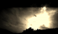
| Polar Updraft Storms |

|
| Previous Image | Next Image
|
Description: Our winter weather in Paekakariki has been deteriorating for a number of years now, particularly with the mid latitude westerlies here. In 2013, is really picked up speed. The SE is dynamite here and comes straight off the 720m high Mt Wainui, which is part of the Akatarawa range. Paekakariki is 100% orographic and the SE can cause massive lee pressure drops here. The reason for the deterioration is Orographic Climate Change. Yep it's here, NZ is not exempt, and we've kicked it off. The worst thing we've been getting over winter is a beast known as a polar updraft storm, which forms here. They start as literal big updraft blastings in our streets or on the hills, with pressure in the 970's. 971 hPa is not unknown here, while Paraparaumu just 10 km's away is 1004 hPa at the same time. In winter 2013, our climate degraded big time, with ice storms in the hills, which exploded into updrafts as they came down here. So the next step is US style ice storms in Paekakariki itself and probably hoar frosts. Wicked to think this could happen in the North Island, everyone expected this outcome in the Southern Alps, but nope, it is here. Meanwhile we await NIWA's findings as to our future outlook, but it does look grim. Climate Change is a nasty beast and it sux. This one is of a polar updraft forming on the rear flank of an ice storm, looks nice bit it was 3C. They sweep us at ground level. The polar updraft storms here are the first in New Zealand.
Picture Stats:
Views: 2450
Filesize: 131.83kB
Height: 922 Width: 692
Posted by: cupoteacoast April 14, 2014, 12:10:31 AM April 14, 2014, 12:10:31 AM
Exif data
| Date Taken |
May 28, 2013, 4:55 pm |
Rating:  by 1 members. by 1 members.
|
| 0 Members and 1 Guest are viewing this picture. |
| Related Images |
Polar Updraft Storm


Views: 2016
Date: April 14, 2014, 12:19:25 AM
Comments (0)
By: cupoteacoast
| Shallow Polar Air Mass ex Antartica

Views: 2516
Date: September 11, 2015, 03:52:37 AM
Comments (0)
By: cupoteacoast
|
|
|