|
|
|
| Trapped NW |

|
| Previous Image | Next Image
|
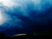
Description: Here the Nor Wester cloud was so low down that it failed to make the uplift, colliding with our hills, and it rained like hell in the process. Cause was a cold Southerly blasting out above the NW, trapping it. That causes so much trouble here, as westerly versus westerly from either side of NZ, with us smack bang in the firing line. A continual line of small funnel clouds and little tornadoes with much black scud ensued over Paekakariki after this. The white foggy stuff is salt spray ex the trapped westerly.
Picture Stats:
Views: 4312
Filesize: 139.08kB
Height: 1200 Width: 1600
Posted by: cupoteacoast September 11, 2015, 03:39:53 AM September 11, 2015, 03:39:53 AM
Rating: This picture has not been rated yet.
|
| 0 Members and 1 Guest are viewing this picture. |
|